

Blog Posts Archive
Posts Categorized With:
"Segregated Sands"

Augustine Beach is located on the ancestral homeland of the Lenni-Lenape people. It is located in northern Delaware along the west bank of the Delaware River, south of the Chesapeake and Delaware Canal, in New Castle County. This land was granted to Augustine Herman, a surveyor who journeyed to Virginia and Maryland, creating a map […]
Read More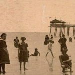

Bethany Beach is on the ancestral land of the Nanticoke people. It is located along the Atlantic coast of Delaware between Indian River Bay and Miller Creek in Sussex County. Bethany Beach was established as a church campsite for the white European members of the Disciples of Christ, located in the Washington, DC area and […]
Read More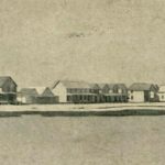
Bowers Beach is located along the west coast of the Delaware Bay between St. Jones River to the north and the Murderkill River to the south in Kent County. It is the ancestral homeland of the Lenni-Lenape people. We know very little about the leisure activities at Bowers Beach during the early twentieth century and […]
Read MoreEfforts to expand The Plantation Stories Project, which aims to capture the stories of African American people who were oppressed and marginalized at the John Dickinson Plantation, continue.
Read More
Jason’s Beach is located on the ancestral homeland of the Nanticoke people. It is located along the southeastern perimeter of Trap Pond in southwest Sussex County. It is the only inland beach in the digital exhibit on Delaware beaches frequented by Black people during the Jim Crow era of the United States in Delaware. The […]
Read More
Lewes Beach is a part of the ancestral homeland of the Big Siconese people of Sickoneysincks Kill. The Big Siconese people were an Algonquin speaking people of the area. They were known as the “ancient ones” by many other tribes and were often called on to settle disputes between tribes. They first came into contact […]
Read More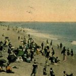
Rehoboth Beach is located in the southern area of the ancestral homeland of the Big Siconese, also known as the Lenni-Lenape people, similar to Lewes Beach. This land is located along the southern Atlantic coast of Delaware, between Delaware Bay and Rehoboth Bay in Sussex County. In the eighteenth and nineteenth centuries, the land was […]
Read More
The land in the twentieth century known as Rosedale Beach has a long complicated history encompassing the Nanticoke people, white European settler colonialism which first began in the seventeenth century, slavery, and then formerly enslaved African American people that settled in the area. The Nanticoke people, also known as the “tidaewater people” of the area […]
Read More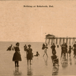
Image: August 15, 1900 announcement in the Smyrna Times about the “Colored Day” at Woodland Beach. Beach-going was no exception to the state-sanctioned segregation laws of the twentieth century. Many of the beaches discussed in this digital exhibit were either designated locations for Black beach-goers to visit anytime they desired or had a specific day […]
Read More
Big Stone Beach, Cedar Beach, and Slaughter Beach are located on the ancestral homeland of the Lenni-Lenape people. Big Stone Beach is located on the west coast of Delaware Bay, in Kent County. Cedar Beach and Slaughter Beach are further south along the west coast of the Delaware Bay in Sussex County. They are all […]
Read More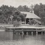
Strawberry Landing is on the ancestral homeland of the Nanticoke people. The beach is located along Miller Creek on the west side of Assawoman Bay in southern Sussex County. This was the segregated beach informally designated for Black people, while nearby Mulberry Landing was for white people only. Charles Laws remembers it as a community […]
Read More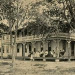
Image: Hotel at Woodland Beach – stamp: 1c Benjamin Franklin, Delaware Public Archives, RG 9015-028-000 Caley Postcard Collection. View the original source at Delaware Public Archives. Woodland Beach is located along the west coast of Delaware Bay in Kent County. Woodland Beach is located on the ancestral homeland of the Lenni-Lenape people, similar to Augustine […]
Read More